
Faisalabad, often called the “Manchester of Pakistan,” is one of the country’s most dynamic and well-planned industrial cities. A detailed map of Faisalabad reveals its unique radial layout, which distinguishes it from other major cities. The city was originally designed during the British colonial period, with the famous Clock Tower (Ghanta Ghar) at its center and eight bazaars radiating outward in a geometrical pattern. This map design is both symbolic and functional, reflecting the organized development of Faisalabad’s commercial and residential zones. In this article you will find the latest Faisalabad map, list of its tehsils and latest population statistics.
Faisalabad is the second most populous district in Punjab, Pakistan. It is one of the divisions of Punjab. Its old name is Lyallpur. Its present name is kept in the honor of late king of Saudi Arabia namely Shah Abdul Bin Abdul Aziz who was a friend of Pakistan. It is famous for industries especially textile.
Population:
According to 2023 census, population of Faisalabad District is 9,075,819, total number of households is 1,384,668, average household size is 6.55, while growth rate is 2.3. According to 2017 census, its population was 7,882,444.
Faisalabad Map:
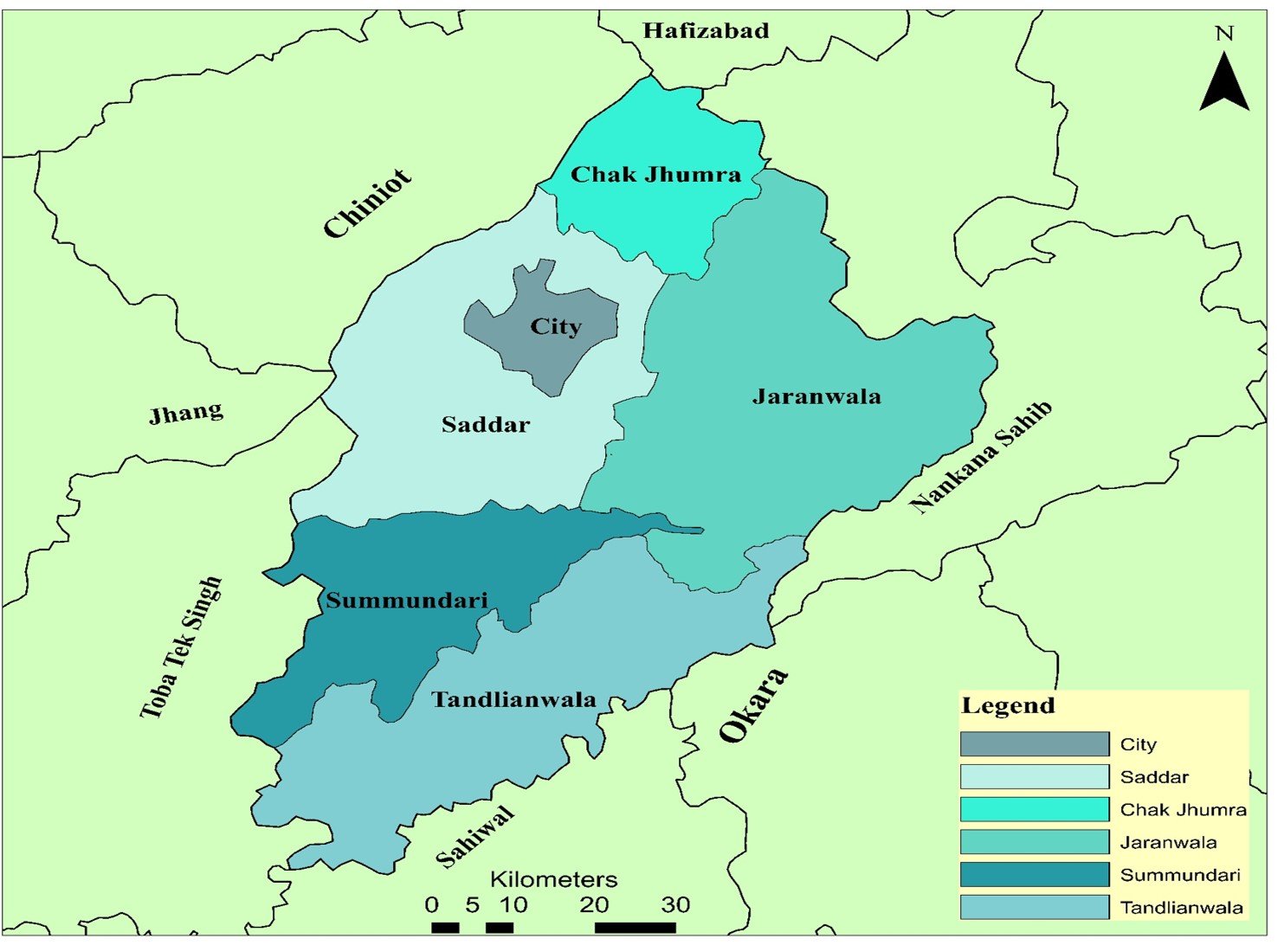
Following is the map of Faisalabad district which shows its tehsils as well:
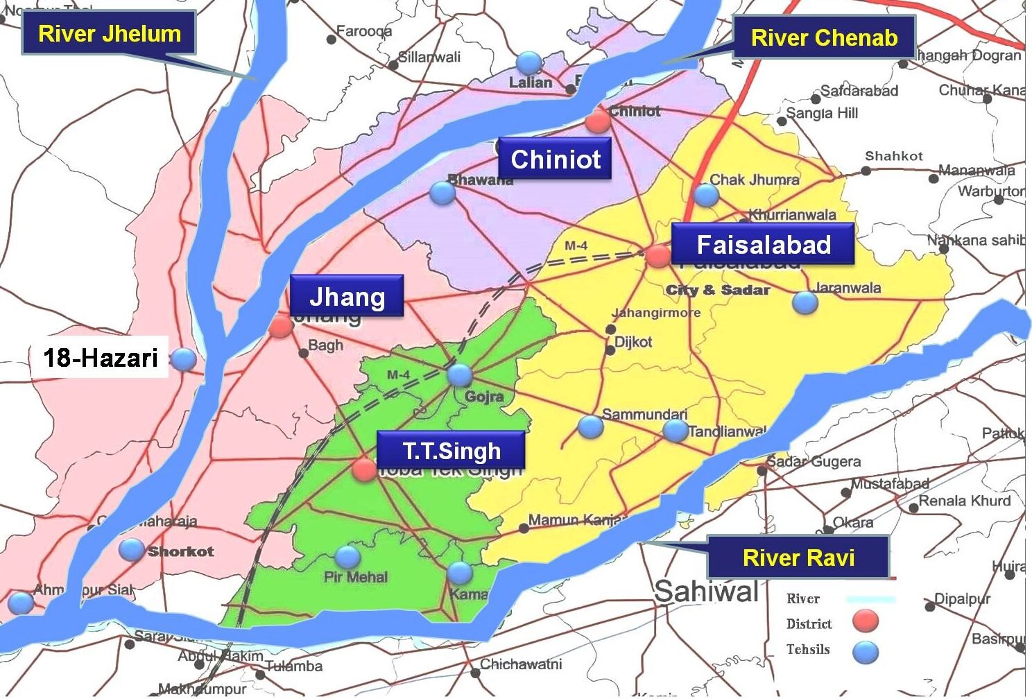
Faisalabad Division Map:
Following is the map of Faisalabad division. This division consists of four districts i.e Faisal Abad, Jhang, Chiniot and Toba Tek Singh.
Google Map Of Faisalabad:
Faisalabad Map Showing Towns:

Geographic Overview:
Faisalabad lies in the fertile plains of Punjab, roughly 120 kilometers west of Lahore. On the map, the city is surrounded by an intricate network of canals branching from the lower Chenab River, which nourishes its vast agricultural lands. Major arteries such as the Jhang Road, Sheikhupura Road, and Faisalabad-Samundri Road connect the urban core to its peripheral tehsils—Jaranwala, Tandlianwala, Chak Jhumra, and Samundri. The M4 Motorway runs through the southern part of the district, linking it to the national highway system and enabling quick transport of goods between Faisalabad, Multan, and Lahore.
On a modern digital map, the Clock Tower remains the unmistakable hub. From it, the eight bazaars—Katchery Bazaar, Aminpur Bazaar, Chiniot Bazaar, Bhawana Bazaar, Jhang Bazaar, Montgomery Bazaar, Rail Bazaar, and Karkhana Bazaar, spread like spokes of a wheel. This design ensures direct access to the city center from every direction. North of the Clock Tower lies the University of Agriculture Faisalabad, one of Asia’s leading agricultural research institutions. The map also marks the industrial zones along the Khurrianwala and Sargodha Road corridors, where major textile and manufacturing plants operate.
Police Stations, Schools & Governance:
There are 42 Police stations in this district. This district has 10 National Assembly seats and 21 seats of Provincial Assembly of Punjab. It got the status of a district in 1904 and divisional status in 1982. There are 1082 Govt schools for boys and 1126 schools for girls in this district. There are 16 rural health centers and 168 basic health units in it. Among the famous hospitals are Allied hospital, DHQ hospital, institute of cardiology, children hospital and Govt. General hospital Ghulam Muhammad Abad.
Tehsils of Faisalabad:
Faisalabad comprises 6 tehsils
- Faisalabad City
- Faisalabad Saddar
- Chak Jhumra
- Samundari
- Tandlianwala
- Jarranwala
Textile Industry:
Faisalabad is widely recognized as the textile hub of Pakistan due to the depth and diversity of its industrial base. The city hosts around 137 textile spinning units that form the backbone of yarn production, supplying raw material to downstream industries. In addition, there are nearly 250 textile dyeing and processing units that handle finishing, printing, and value addition of fabrics. Faisalabad also has about 300 embroidery units and 250 hosiery units, supporting both local markets and export-oriented production.
The presence of 175 readymade garment units highlights the city’s growing role in finished apparel manufacturing. With more than 56,038 power looms engaged in weaving and around 150 sizing and cotton ginning units, Faisalabad maintains a fully integrated textile supply chain that significantly contributes to employment, exports, and overall industrial growth.